

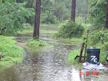
All geared up waiting for the weather to hit and so far..........nothing...ok, just a small squall for about ten or fifteen minutes...the sky continues to show dark clouds with spots of sunshine now and then. Temperatures remain low for now, only 75 degrees at 12:30 pm...the humidity is rising a bit, but still very tolerable. Occasionally, we have a bit of breeze blow through, but so far, nothing threatening. We are forecast for sustained winds of 20-35 mph with gusts up to 60 mph. South of us in our 'neighboring' county, they are currently being blasted by the winds as the storm moves further inland. Flooding is the main concern from the rain being dumped by the storm bands....that and tornadoes being spawned by the churning winds.
Our east coast beaches are being pounded more than expected from this storm, erosion is always a big concern, especially since they've spent MILLIONS replacing the sand that is constantly dragged out by the ocean....
From the weather map showing right now, the winds are getting closer to our area, I think they were saying something about us getting the worst weather after 2 pm. The storm winds have not dropped since it came onshore, a bit unusual, but the forecasters are saying its being fed by all the water from the rivers, Everglades and lakes that are in the area where the storm is currently sitting. The way they are talking, they expect the storm to cross on through the state and come out below us in Brevard county....guess we shall see...then they expect it to take a westerly turn and come back in around Jacksonville / St Augustine area...hmmmm, I believe we've had similar action from a few other storms in the recent past....
Holding our breath, waiting for the storm to pass.......not really, YAAAWWWNNN....I'm over it already. More updates later as the afternoon passes and the storm begins to do its thing in our area.
Basics 101...Food...Recipes with Leftovers
17 years ago
No comments:
Post a Comment